Date: July 26, 2014
Location: Flagstaff AZ
Hikers: Me & Tina
Directions:
Take I17 North towards Flagstaff. Take Lake Mary Road Exit. Exit 339. Take Right at end of Ramp. (There is a Circle K right at the North of the road) Follow Lake Mary Road for 5.3 miles. Look for Canyon Vista Campground on the left. Turn in. Parking is before the campground entrance. Trail head is thru the camp ground at the far end. Restrooms/ No Water
Sandy Canyon:
http://www.fs.usda.gov/wps/portal/fsinternet/!ut/p/c4/04_SB8K8xLLM9MSSzPy8xBz9CP0os3gDfxMDT8MwRydLA1cj72BTJw8jAwjQL8h2VAQAzHJMsQ!!/?ss=110304&ttype=recarea&recid=55034&actid=104&navtype=BROWSEBYSUBJECT&position=BROWSEBYSUBJECT&navid=110000000000000&pnavid=null&cid=FSE_003741&pname=Flagstaff+RD+-+Sandys+Canyon+Trail+%23137
Marshall Lake:
http://www.fs.usda.gov/recarea/coconino/recreation/hiking/recarea/?recid=55060&actid=50 and
http://www.fs.usda.gov/wps/portal/fsinternet/!ut/p/c5/04_SB8K8xLLM9MSSzPy8xBz9CP0os3gDfxMDT8MwRydLA1cj72BTn0AjAwgAykeaxcN4jhYG_h4eYX5hPgYwefy6w0H24dcPNgEHcDTQ9_PIz03VL8iNMMgycVQEADoWIdk!/dl3/d3/L2dJQSEvUUt3QS9ZQnZ3LzZfME80MEkxVkFCOTBFMktTNUJIMjAwMDAwMDA!/?ss=110304&navid=110000000000000&pnavid=null&cid=FSE_003741&recid=75328&ttype=recarea&navtype=BROWSEBYSUBJECT&position=BROWSEBYSUBJECT&pname=Coconino+National+Forest+Recreation+-+Marshall+Lake


Back to the Canyon Vista Campground for a new hike. Same Parking lot as our Sandy Canyon hike earlier this year. This time we are heading to Marshall Lake which is a 4.6 one way off of the Sandy Canyon trail.
It is very hot in Phoenix right now with Monsoon activity and humidity. Tina and I decided to head North to cooler temperatures and get in at least a 9 mile hike.
 Originally we were going to Red Mountain/Coconino National or Bismarck Lake but we decided to go less into Flagstaff.

 We left Phoenix at 6AM and hit the trailhead at 7:30. The temperature was amazing. Although it did not feel as cool as it says.


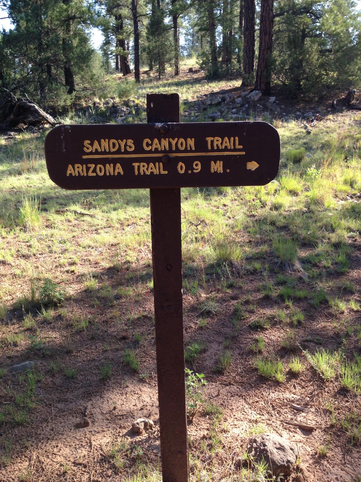
We will be hiking another part of the Arizona Trail. Now that I am aware of it I have checked out many of the trails. The trail heads East out of Flagstaff so maybe I can find some more opportunities to be on parts of it. Below is a little more detail on what is on the sign.
We followed the same path as hike #40 to the bottom of Sandy Canyon. The views were beautiful. There was smoke in the air from the controlled burns. Although on the way up on I17 from Sedona to before Lake Mary there was a lot of smoke and Hot Shot Fire trucks drove by the entrance to the Trailhead.


At about 1 mile in we see the sign for Marshall Lake. We stopped and talked to three other hikers. They said it was a short steep hill up and then pretty flat to Marshall Lake. That short comment was a lie!! It was about 1 mile of up.
 We hit the trail and up we went.

 The walls at the bottom of the canyon are Awesome to see. The colors are very pretty.
The path was like a pasture but it quickly turned to woods and a rocky path. Our favorite type of trail where you twist your ankle and are off balance. It's all about the Core workout.


As we turn around we can see the view of Mount Humpreys. Pretty to think we were at the top of that on hike # 41 back in June. (well almost at the top)

 The trail is covered with burnt trees and stumps. There was a fire in 2013 at Fisher point that was set by a person. Not sure if it is from a controlled burn or the fire. The altitude definetly can be felt on this hike. We are at 7000 ft and it does make a different as you head up the hill
 Again we see the markers on the tree for the Arizona Trail. We passed a couple dirt roads that are probably used by the Lumber Jacks. :)


It flattens out quickly. We are walking through the forest. We talked about poison ivy, horny toads and what to do if a Bear were to approach us. We need to research that.

 We saw a little Horny Toad on the path.
Jim and I saw them last time in this area. I think these are cute. I don't jump when they cross my path.
We decided that we would hike to 6 miles on my GPS and then turn around at that point. A 12 mile hike will be perfect. We should hike Marshall Lake based on the miles of the signs.
Sandy Canyon:
http://www.fs.usda.gov/wps/portal/fsinternet/!ut/p/c4/04_SB8K8xLLM9MSSzPy8xBz9CP0os3gDfxMDT8MwRydLA1cj72BTJw8jAwjQL8h2VAQAzHJMsQ!!/?ss=110304&ttype=recarea&recid=55034&actid=104&navtype=BROWSEBYSUBJECT&position=BROWSEBYSUBJECT&navid=110000000000000&pnavid=null&cid=FSE_003741&pname=Flagstaff+RD+-+Sandys+Canyon+Trail+%23137
Marshall Lake:
http://www.fs.usda.gov/recarea/coconino/recreation/hiking/recarea/?recid=55060&actid=50 and
http://www.fs.usda.gov/wps/portal/fsinternet/!ut/p/c5/04_SB8K8xLLM9MSSzPy8xBz9CP0os3gDfxMDT8MwRydLA1cj72BTn0AjAwgAykeaxcN4jhYG_h4eYX5hPgYwefy6w0H24dcPNgEHcDTQ9_PIz03VL8iNMMgycVQEADoWIdk!/dl3/d3/L2dJQSEvUUt3QS9ZQnZ3LzZfME80MEkxVkFCOTBFMktTNUJIMjAwMDAwMDA!/?ss=110304&navid=110000000000000&pnavid=null&cid=FSE_003741&recid=75328&ttype=recarea&navtype=BROWSEBYSUBJECT&position=BROWSEBYSUBJECT&pname=Coconino+National+Forest+Recreation+-+Marshall+Lake
Back to the Canyon Vista Campground for a new hike. Same Parking lot as our Sandy Canyon hike earlier this year. This time we are heading to Marshall Lake which is a 4.6 one way off of the Sandy Canyon trail.
It is very hot in Phoenix right now with Monsoon activity and humidity. Tina and I decided to head North to cooler temperatures and get in at least a 9 mile hike.
We left Phoenix at 6AM and hit the trailhead at 7:30. The temperature was amazing. Although it did not feel as cool as it says. We will be hiking another part of the Arizona Trail. Now that I am aware of it I have checked out many of the trails. The trail heads East out of Flagstaff so maybe I can find some more opportunities to be on parts of it. Below is a little more detail on what is on the sign.
We followed the same path as hike #40 to the bottom of Sandy Canyon. The views were beautiful. There was smoke in the air from the controlled burns. Although on the way up on I17 from Sedona to before Lake Mary there was a lot of smoke and Hot Shot Fire trucks drove by the entrance to the Trailhead.
At about 1 mile in we see the sign for Marshall Lake. We stopped and talked to three other hikers. They said it was a short steep hill up and then pretty flat to Marshall Lake. That short comment was a lie!! It was about 1 mile of up.
The walls at the bottom of the canyon are Awesome to see. The colors are very pretty. As we turn around we can see the view of Mount Humpreys. Pretty to think we were at the top of that on hike # 41 back in June. (well almost at the top)
It flattens out quickly. We are walking through the forest. We talked about poison ivy, horny toads and what to do if a Bear were to approach us. We need to research that.
Jim and I saw them last time in this area. I think these are cute. I don't jump when they cross my path.
 |
| Cool Tree |
Marshall lake is dry but I read that in spots it is Marshy. We did not continue to the end to find a sign because we decided to turn at 6 miles. From all the pictures I have seen this is part of the Lake.


 We took a quick break for a snack and some electrolytes. We touched our toes and stretched. Yea Right. We talked about hiking the grand canyon and making sure we eat and hydrate properly.
Tina showed her strength by parting the trail for me.
We hit the juncture of Sandy Canyon. We passed two families at that point. Other than that we saw one biker and two horses on the Marshall Lake trail. It was very nice not seeing anyone. My phone was dying and we were determined to keep the stats on MapMyHike. We did it. The phone died as we saw the parking lot and at 12 miles I saved it.
It was a great hike. Harder than expected. Which is why you must sign a waiver before you hike with me. Great workout. Bring on the Canyon!
We stopped for a cold drink before hitting the highway. Looking forward to the temperature back in Phoenix upon our return. We wanted to be back in Phoenix so we could do to Dip at night. It's all about the Dip!


We took a quick break for a snack and some electrolytes. We touched our toes and stretched. Yea Right. We talked about hiking the grand canyon and making sure we eat and hydrate properly. Tina showed her strength by parting the trail for me.
 |
| Lava Rock in the base of the Canyon |
It was a great hike. Harder than expected. Which is why you must sign a waiver before you hike with me. Great workout. Bring on the Canyon!
We stopped for a cold drink before hitting the highway. Looking forward to the temperature back in Phoenix upon our return. We wanted to be back in Phoenix so we could do to Dip at night. It's all about the Dip!
Hike #47 Done!
Check it off!
No comments:
Post a Comment