Date: May 25, 2014
Location: Phoenix AZ
Hikers: Me, Jim & Tina
Directions:
Make your way to Highway 60. Take it East towards Apache Junction. Travel 7.6 miles East of the junction Idaho Rd/US-60. Turn left on to FS77 which is Peralta Road. Follow FS77 5.6 miles to a left and up turnoff. Continue 0.6 miles to Carney Springs Trailhead. No Water and No Restrooms.
Carney Springs Trailhead:
http://www.superstitionwildernesstrails.com/maps.html
Take 2! or Is it Take 4. Back out to the Superstition Mountains. Refer to Hike #33. This time trying to find the Wave Cave. The comment before we start the hike. "We will find it this time". Read on.
 This is probably the last 90 degree weekend in AZ so Tina, Jim and I decide to go find the Wave Cave. We are hitting the trail at 7:30 and it is a beautiful 68 degrees. That is rare for a late May morning. No breeze or clouds in the sky.
 Jim forgot a hat so he found a bandana in Tina's truck. Woof Woof Bow Wow Rag do!
Same picture as before. The shot of the Wave Cave in the distance. We are excited because I am looking forward to the cool picture from inside. It's all about the picture.

 We are heading up the Carney Springs trail. Crossing the gate at the Wilderness point. Staying straight on the trail until we hit the infamous Mesquite tree on the left where you see a trail off to the left (East). This time the rocks that had blocked the trail last time were kicked away. So if you read other trip reports know that things change daily. We do see the Cairns that show you can go that way. We love Cairns. GRRRR. Not on this trip....read on!
This time we forged quickly ahead. There was no one on the trail. I looked for Cairns all around since last time with Julio we followed Cairns going up the hill higher than we should. So at one point we saw some up and down. We chose down since I knew we had to get into the wash to travel north.
I filled Tina and Jim in on my last attempt at the Wave Cave and how I thought Julio and I were close and this would be a piece of cake. I was cautious of the Cairns and had also taken a snap shot of a trip report that had been done in the past. (See below)

We hit the two paths that would enter us into the wash. Let me tell you that neither path was a prize. It was all lose dirt and rock. Jim had poles which was a plus. (weapons to be used later).

 Once in the wash we hopped over boulders heading north. Per the trip report we were following Cairns and looking for the pointy boulder. Our mixed message was the "some distance (just a couple tenths)". We headed out of the wash on another steep climb up. Once up we saw Cairns so we were feeling pretty good. Well the Cairns became less and the bushwhacking became extreme. We were not on a trail. We were in the desert. Our legs were getting ripped up pretty good. We continued in a North East direction.
As the trail (word used very lightly) continued towards the Cave we decided to leave Jim at a small cave. Tina and I headed up so we could do some scouting but it really did not feel right.

 Jim found that one of the little caves had someone living in it recently or partying. Although not my idea of a party place.
Tina and I kept saying this is not right, we need to stop and then the other would say oh wait maybe over here. We are a bad team SOMETIME. We realized that we were under a cave but not the right one. We could see the Wave Cave to the North of us. We must have come out of the wash too soon. I re-read the directions and that was the only thing. The problem was we were following Cairns. Well someone else must have marked that area to get to the "Party Cave". GRRRRR.


 At this point we are all bushwhacked out. We are scrapped up. We have been in places that we should not have been in and we are probably lucky no one has slipped. We Marco Polo to get back to Jim and decided to head south along the wash vs getting in the wash. The place we came out of it was pretty steep, so if possible we will get in further down the trails. To our surprise NOT. We see more Cairns. We have an adjective that starts with an F for these Cairns but I will keep this PG Rated.
If you look at the picture below you will see two sets of caves. Two on the right and then one further on the left by itself. Tina and I were at the left one. :( Jim was in the little one between the two. It's an Adventure....Remember?

As we head back we are crossing bushes, Tina and I used one glove each that I had in my Camelback and Jim had his poles. Tearing up our legs. As we grumbled on our way back we are walking single file really close to each other. All of a sudden Jim Yells. WOOO a Snake. Tina jumps gently back and I SCREAM. Jim's pole hit a Rattle Snake. As he moved back the snake turned to move away but then looked back ready to strike. I of course woke the valley and sprinted backward. Not that there were any other snakes. It was a great story on the way back to the car.
No picture provided. Google a Rattle Snake on your own time. HA HA.
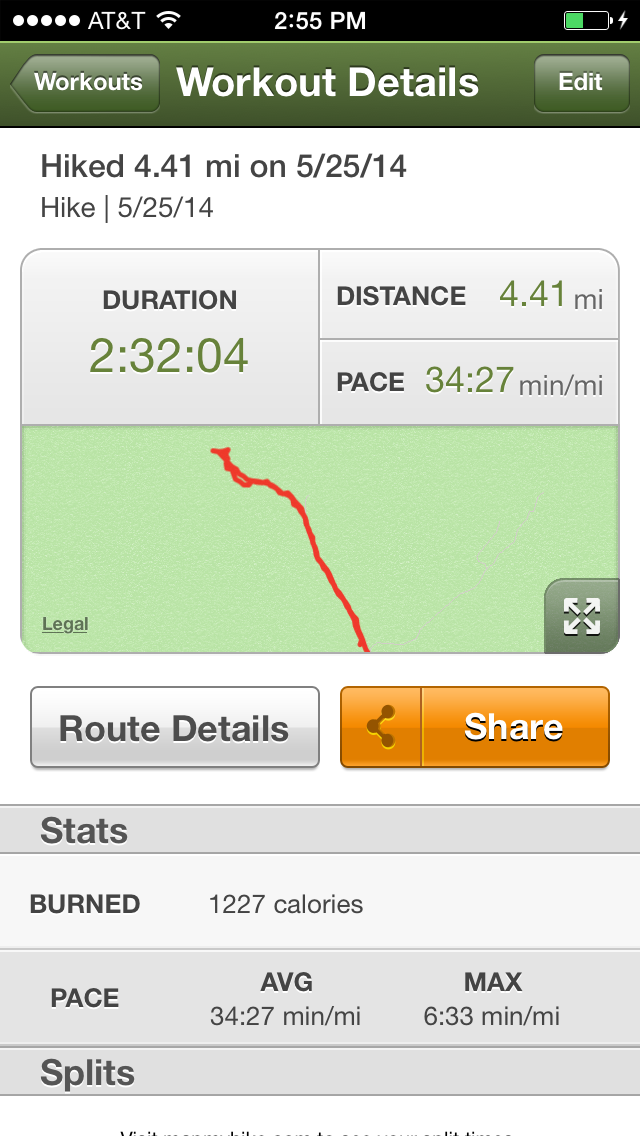
We crossed the wash still bushwhacking but better than before. We reached the other side and bushwhacked to get back to the Cairns. We found them and took the trail back. At that point my MapMyHike told me we had gone three miles in 2 hours. Are you Kidding Me!!
We got back to the car. The last mile we started singing the song "Let it Go". This hike will not haunt me like Siphon Draw did. For months I was frustrated that I could not scale that wall. This one...won't haunt me. Maybe I will go back in the Fall/Winter with long pants on but it won't keep me awake at night.
This route detail KILLS me. We were so close but we got out of the wash too soon. The blue line is the trail. I guess if you want to do this right you should get a real GPS and the coordinates.

Carney Springs Trailhead:
http://www.superstitionwildernesstrails.com/maps.html
Take 2! or Is it Take 4. Back out to the Superstition Mountains. Refer to Hike #33. This time trying to find the Wave Cave. The comment before we start the hike. "We will find it this time". Read on.
This is probably the last 90 degree weekend in AZ so Tina, Jim and I decide to go find the Wave Cave. We are hitting the trail at 7:30 and it is a beautiful 68 degrees. That is rare for a late May morning. No breeze or clouds in the sky. Jim forgot a hat so he found a bandana in Tina's truck. Woof Woof Bow Wow Rag do!Same picture as before. The shot of the Wave Cave in the distance. We are excited because I am looking forward to the cool picture from inside. It's all about the picture.
We are heading up the Carney Springs trail. Crossing the gate at the Wilderness point. Staying straight on the trail until we hit the infamous Mesquite tree on the left where you see a trail off to the left (East). This time the rocks that had blocked the trail last time were kicked away. So if you read other trip reports know that things change daily. We do see the Cairns that show you can go that way. We love Cairns. GRRRR. Not on this trip....read on! |
| Hitting the Trail |
 |
| This Cactus doesn't know which way to go either. |
We hit the two paths that would enter us into the wash. Let me tell you that neither path was a prize. It was all lose dirt and rock. Jim had poles which was a plus. (weapons to be used later).
Once in the wash we hopped over boulders heading north. Per the trip report we were following Cairns and looking for the pointy boulder. Our mixed message was the "some distance (just a couple tenths)". We headed out of the wash on another steep climb up. Once up we saw Cairns so we were feeling pretty good. Well the Cairns became less and the bushwhacking became extreme. We were not on a trail. We were in the desert. Our legs were getting ripped up pretty good. We continued in a North East direction.  |
| The point rock to get out of the Wash....Not pointy enough! |
 |
| Feeling Confident! |
Jim found that one of the little caves had someone living in it recently or partying. Although not my idea of a party place. Tina and I kept saying this is not right, we need to stop and then the other would say oh wait maybe over here. We are a bad team SOMETIME. We realized that we were under a cave but not the right one. We could see the Wave Cave to the North of us. We must have come out of the wash too soon. I re-read the directions and that was the only thing. The problem was we were following Cairns. Well someone else must have marked that area to get to the "Party Cave". GRRRRR.
If you look at the picture below you will see two sets of caves. Two on the right and then one further on the left by itself. Tina and I were at the left one. :( Jim was in the little one between the two. It's an Adventure....Remember?
No picture provided. Google a Rattle Snake on your own time. HA HA.
We crossed the wash still bushwhacking but better than before. We reached the other side and bushwhacked to get back to the Cairns. We found them and took the trail back. At that point my MapMyHike told me we had gone three miles in 2 hours. Are you Kidding Me!!
We got back to the car. The last mile we started singing the song "Let it Go". This hike will not haunt me like Siphon Draw did. For months I was frustrated that I could not scale that wall. This one...won't haunt me. Maybe I will go back in the Fall/Winter with long pants on but it won't keep me awake at night.
This route detail KILLS me. We were so close but we got out of the wash too soon. The blue line is the trail. I guess if you want to do this right you should get a real GPS and the coordinates.

Lessons learned on this one.
1. Use a GPS
2. Wear Long Pants
3. Know that Trip reports are not perfect
4. Don't assume all Cairns are taking you to where you think
 |
| Cairn's aren't your friend! |
It was a fun hike! I can only imagine how many snakes we really walked over!
Happy Memorial Day! #37....Check it off!!


