Sunday, December 1, 2013

Hike #7 - Spur Cross Ranch - Elephant Mountain Cave Creek AZ

Hike #7

Date: November 30, 2013 
Location:  Cave Creek AZ
Hikers: Tina, Linda & Jim


Directions: From Phoenix get to Cave Creek Road head North. Take all the way into the town of Cave Creek. Turn Left on Spur Cross Road. Stay Right at the Curve.  Follow 4 miles to trailhead. Parking cost $3 per car.  Not sure about Water. Restrooms available.  

http://www.maricopa.gov/parks/spur_cross/

Our plan today is to do Elephant Mountain at Spur Cross Ranch Conservation Area.  We were planning to do this last week but it was raining.  Good thing we did not because there are a lot of washes that we would have been hiking thru water.  It was a cool Arizona morning mid 50s. 

Elephant Mountain looks like the side view of an Elephant Head.  From Carefree you can see the profile.  Use your imagination from left to right is his head with ears, eyes shut and then his trunk. There are better profile pictures but driving and trying to get a shot is not the easiest.

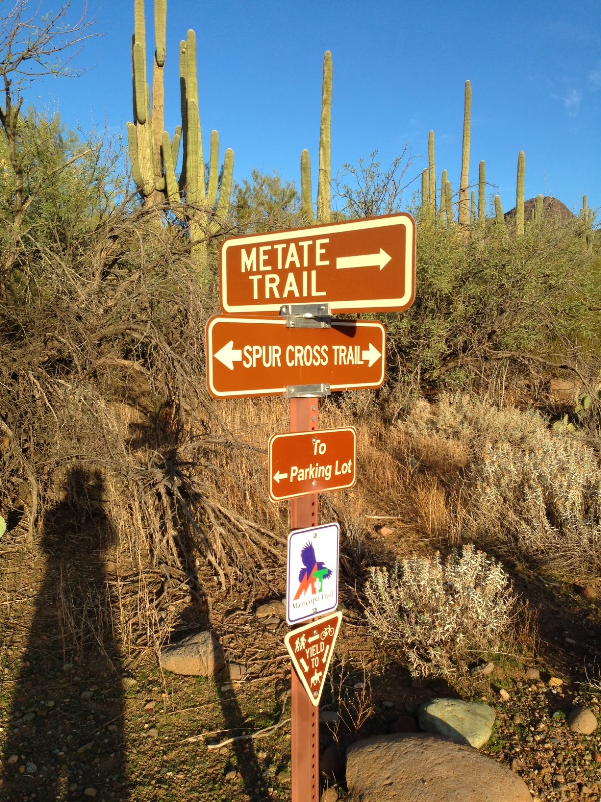
There is a fee of $3 to park.  You must fill out an envelop at the trailhead.  (Remember your license plate # - we didn't).                  Trail maps are available also. Take one you will need it! 


WARNING!! Always be aware of your surroundings.  There are strange animals in the wilderness.  We saw this crazy animal at the trail head. LOL!!

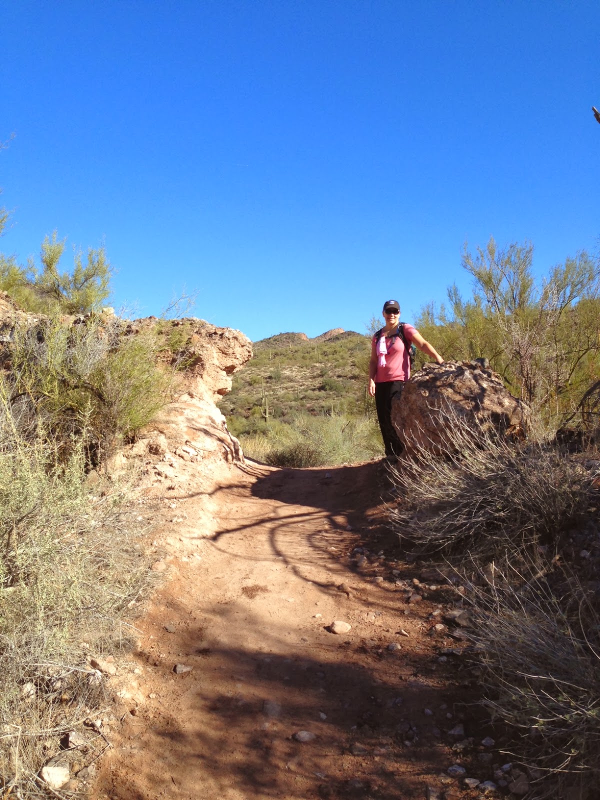
We are doing the Elephant Mountain Loop which is about 6.6 miles.  We chose to start at Spur Crossing Trail and head to the left (west). There is a very gradual up at first.  The terrain is the loose rocks.  Not my favorite but just wait it will change as you go higher in elevation. 
 This part of the trail is very well marked with the trail markers you see.  As we get into Elephant Mountain it gets less marked and a little confusing.  We were no longer cold at this point.  The sun was a welcome treat.
 We walked up hill for a while and then down into a wash.  The markers stopped at this point but thanks to the Rock Stacker Men (that is what Tina calls them) we were able to see where to walk to eventually pick up the trail but know we were heading in the right direction.

The wash walking did not last long.  We picked up the trail and now we were heading UP to Elephant Mountain. This part of the trail is rated two diamonds. Extreme.  It is now all up.  The summit of the Elephants nose is where we are heading.  The Elevation is 3342 so we did a pretty good climb.


 This spot is where we were a little confused.  We thought we were going around the elephants head vs over the nose.  We continued up vs to the right.  We believe the right would have been how we came up if we took the East trail at the beginning of the hike
We took the right path. We were at the top of Elephant Mountain.  We could see Black Mountain and the McDowells directly south. We could see Pinnacle Peak and Toms Thumb.  Great Hike. Now to head down!
Heading down there are lots of Saguaro Cactus. It is pretty cool how the terrain quickly changes.

Jim catching up after a pit stop! 
Dead Cactus that looks like a scary ghost!
We had a great hike. Enjoy some fun conversation.  Disclaimer: Nothing discussed can be used on the blog! Although I think I am missing something now watching Once Upon a Time! Something about Captain Hook. :)

We met up with a couple people heading up on this side. Other than that we saw only one person up the beginning of the hike.  There are not a lot of people using this trail.  It does state that it is primitive. Honestly, it is not that bad or primitive. The down was easier.  If you are looking to do this hike and you do not like to do up, you may want to do this the opposite route that we did.                        
        
Merging onto Spur Crossing. My Elephant Impersonation
Tina loves having her picture taking!
This was a post Thanksgiving weekend Hike.  It was a challenge and different from the others.  I think we could do this again and take a different route.  This was a 6.6 mile hike. (my GPS was off).  us little less than 3 hours with stop and snack. 
I am thankful for my hiking buddies on this adventure. As always, we had fun!  I am thankful for my health to be able to do this and the nature in this great state of AZ! 
Lucky 7 Done! 

Happy Thanksgiving! 


Monday, November 18, 2013

Hike #6 - Toms Thumb via East End/Windgate (Full Loop)


Hike #6

Date: November 16, 2013 (Birthday shout-out to Steve, Michelle & Jerry)
Location:  Scottsdale AZ
Hikers: Linda & Jim


Directions: From Scottsdale Rd or Pima Rd, turn East onto Happy Valley Rd. Proceed about 2 miles past Alma School and turn right (East) onto Ranch Gate. Proceed to the end of Ranch Gate and then turn right (South) onto 128 St and you'll arrive at the trailhead in less than a mile. Restrooms available. NO Water. 

http://www.mcdowellsonoran.org/trailhead/displayLocation/8#sthash.LxrqDYkh.dpuf


In my quest to continue to find NEW hikes I decided to turn an old favorite into a new adventure.  Toms Thumb is a great trail.  It is a steep incline and now that there is an official trailhead the trail is highly used and erosion is occurring.  Be careful! 

On the drive to meet Jim at 7 am.  I felt like I was driving in Hawaii. (I have never been to Hawaii so it is just a guess). The clouds were low over the McDowell Mountains as the sun tried to rise. However the rainy overcast sky looked very eerie.  I love this weather!! Feels like home!  The plan for today is an 11 mile hike.  It's gonna be a GOOD one! The little thimble sticking up is Toms Thumb.  Looks so close.  NOT!
Tom's Thumb Trailhead North Side
Jim reminded me not to leave valuables in the car. There have been a lot of break-ins at this parking lot.  Of course I threw my purse in the trunk.  Probably should stop doing that.  


We headed up the trail with a light sprinkle and low fog clouds.  It felt great.  We brought poles today because I heard that the East End Trail is steep.  It is about 1.6 miles to the top of Tom's Thumb where we planned to pick up the East End Trail.  I took a couple pictures and I hear Jim say "who are you, Julio?"  Well, yea how else can I blog about my hike.
Options! 
We made it to the Junction of the East End Trail in a quick 30 minutes.  Per the map that is a 1.6 mile hike from the trailhead.  I realized that my GPS was messed up.  It was tracking us but not like normal.  Oh Well.  We then headed down the East End Trail.

We did not see anyone on the trail as we headed up.  It is always nice to hike early because there are few people.

The View down the East End Trail was awesome.  On a clear day you can see the fountain in Fountain Hills.  It shoots off water every 15 minutes from 9 to 9.  Check out some info on the Fountain. It is the 4th Tallest in the WORLD!

http://en.wikipedia.org/wiki/Fountain_Hills,_Arizona

We saw two guys coming off the side trail of the East End.  We asked if we were going the right way because there are two trails next to each other.  They said Yeah.  The one on the left was to a cave. They had camped out in a Cave over night. They said it was "that a way" and they probably could never find it again. I am not interested in getting lost. To be young again!


The trail down the East End was very different. The dirt was more like red clay and the trail was steep. We knew that we would have to travel 1.3 miles to pick up the Windgate Pass Trail.  We had hiked Windgate before.  Years ago when we were training for a Grand Canyon hike.  It looks like a pasture in Kansas. Strange when you just came from Clay and Rocks.


We continued to hike but could see to our north west that the sky was pitch black. That was the direction we would be heading to soon.  Jim is lagging behind because there was a tree that he needed to check out! :) We hit Windgate and finally saw someone. There was a runner by himself.  We took a right and headed West on Windgate.  I did not remember it being a slow uphill climb. But it was! We had been hiking for 2 hours.  We saw a Mountain biker go by at this point.  We started talking about food. Our favorite subject. We knew this would be a long hike so we brought snacks.  Jim was yaking about a Cheese Sandwich that sounded Boring!  I of course forgot my sandwich.  HA!  But had almonds, Grapes and an apple.  Good mix of Carbs and Protein.  We decided we would stop at the exact Windgate Pass location between the mountains.
The mountain on the right is what we just went around to the East. Now we will travel West to then hike up the North side to get back to Toms Thumb. It was a little windy but time to make a stop and eat. The sky looked bad but no rain and as we continued West the sky broke up.  No Worries.
As we headed West to pick Tom's Thumb trail we met up with a lady.  She was lost.  She was with a group and she took a break, she saw them on the "other side" and thought she was heading in that direction.  Ahhhh. No!  She was probably a mile past the turn she should of taken to do a 5 mile loop. She was heading for a 10 mile loop.  We turned her around and eventually in the distance she could see her friends.  NOTE: Don't hike alone or separate from your group. Especially if you are on a long trail that you have never done.  Short intown hikes are fine alone, but not in the McDowells.  We pointed her in the right direction and hooked our right to head up 3 miles to Toms Thumb.

This trail is beautiful.  There is a jungle spot with a running stream.  A rock bench that Jim found to be a great place for a break.  You hit switch backs that keep you occupied looking at Cholla and then later Saguaro cactus.  It is a beautiful part of the country and amazing that we are 30 minutes from home.


Up we went.  If you think this was an easy 11 miles, don't kid yourself.  It was tough even for someone that hikes alot.  The inclines up and down do a number on your knees.  Poles definitely help on this hike.  It was windy as we hiked higher.  We stopped for a quick apple break.  We had been hiking for about 4 hours when we hit the top of Toms Thumb.  There were tons of people by now.  Tourists!!  We met up with an Oregon State fan visiting.  Poor Beavers lost to The Sun Devils.  Fear the Fork! (post hike information).

It was a great day.  We finished the 11 miles in about 4 hours 45 minutes with a few stops and some lunch. Another fun day with Jim Croutch.  I can only hope that I have his energy when I am 65!! He is Amazing!

My Mapmyhike did not record properly. Thanks to my IOS upgrade I had the GPS off when the screen saver was on so it thought we went in a straight line for a while and did not record.  Oh Well. *Notes for this hike.  Bring your Camelbak full.  Cool days are no problem, if it was hot we would have needed an extra container hooked on.  Snack are a must. Don't leave your PB&J at home!
Number 6 Done - Check it off!
 Looking for the next New Hike.  Maybe a TurkeyDay Hike?  Lots to give Thanks for!! 

Monday, October 21, 2013

Hike # 5 - West Fork Oak Creek 108 Sedona AZ


Hike #5 


Date: October 20, 2013
Location:  Sedona AZ
Hikers: Linda & Julio

Directions: Drive I17 North to Sedona exit. Head into town. Take Highway 89A north for 9.5 miles to about halfway between milepost 385 and 384. The trailhead is on the west side of the highway down a paved lane that leads behind a few creekside houses. Park at the Call O' The Canyon day-use area.
Day-use is $9 per vehicle (up to 5 people), walk-in, bicycle, bus: $2.00 per person. Restrooms available

Last minute decision to go hiking today. Julio decided to take the afternoon off so we got a late start.  West Fork has been on my to do list for a while.  We headed up there weeks ago but was stopped by rain.  Last week the government had the park shut down and it was a mess. This weekend PERFECT!  Not a cloud in the sky. 70 degree temperatures at the start of a mid day hike. 


Over the years I have hiked alot in Sedona. Most of the Tourist hikes. Here is a short list if you are looking for some good hikes. (Cathedral rock, Bell Rock, Boynton Canyon, Baldwin Trail, Broken Arrow, Devils Bridge, Margs Draw, Slide Rock, Soldiers pass, Voltee Arch) West Fork is one to add to the comeback to list.


We pulled up to a line waiting to get in to the park. At first we hesitated thinking we should leave but we decided to be patient and stick to our plan.  It was a 10 minute wait. As one car exits they let one in.  Not bad.  The price is per car. They also charge if you walk in so keep that in mind.  We definitely got our $9 worth today!

Since my adventure is for NEW hikes we learn something every time.  This time.  Bring a pullover or long sleeves.  There were spots that we were cold going in and definitely out because the sun was coming down.  It is mostly shaded the whole hike. 

We started the hike at 75 degrees. Ended at 56 degrees. 

There is a bridge at the start of the trail over the creek.  Great spot for a picture.  The beginning of the hike is busy.  Lots of families traveling. Once you cross a few streams you see less people.


The hike is an easy 7.2 round trip to the end.  Easy being flat. Although you have to cross streams and there are several spots were you cross tree roots. For someone older or not as steady on the feet it would be a tricky hike. You can hike for a short while just to see the views and the canyon.


First shots of Foliage
The colors of the trees were amazing.  You don't see foliage in AZ often.  This hike reminded me of home in Massachusetts and NH.  We crossed many parts of the creek. The rocks are positioned to make it fairly easy but there are some spots that you can miss a footing and get wet feet. Make sure your shoes are water proof.  The canyon itself is amazing.  Tall and various from the white cliffs to the rock rocks.  Add the colors of the trees change from green to yellow to orange to red.  It is a photographers dream.  Good thing I had my handy dandy photographer with me. 

Julio and I walked and stopped several times.  Great shots for pictures.  We brought our lunch (I was told my lunches are getting better. But make two sandwiches) and enjoyed a sunny spot on a rock next to the creek. I highly recommend this hike in the Fall.  The addition of the tree color made it even more special. I could add 50 great pictures from our hike. Here are just a few (out of the 200 taken) 

Beautiful Foliage with the red rock as the backdrop.  Amazing Colors.  The reflection of the colors against the creek were really cool!! As we traveled along the creek winding back and forth the colors changed
Close up of the branch
I could put many more pictures.  These are a few.  Traveling with a photographer makes the trip even more special.  I could never get these shots with my iPhone.


Shot from a ledge we stood on

View from one side of the canyon


When you reach the turnaround spot, you will see a sign that tells you after that point the hike requires water wading.  It is true.  That is also the point that you can camp.  Before that you can not camp.  No worries here. Camping for me is a Motel 6. 


I am so glad that Julio took the day off. So many pictures for my blog.  I heard that about 100 times!  HA. It was another great adventure. Julio collected two bags on colored leaves. Can't wait to see what he does with those. (before I throw them out)

Here are all the Julio "oh this is a great picture for your blog"shots.  You can only imagine how many more of these there are.....
This was before he started complaining about the cold. :(
Love on the Ledge
Julio used our lunch baggies to collect leaves!
Strike a pose

Warning you may need to move obstacles

If you are not nice I am gonna leave you here

Drink Break
Waiting for people to cross the creek
We ended the day stopping at a deli market on Oak Creek, homemade pastries hit the spot. We then watched the sunset from Airport Lookout before heading home.  Pretty awesome that this is only 1 1/2 hours away from us.  In my opinion Sedona is one of the most beautiful places in the world. We will be back again. I have a few more hikes on my list for Sedona. Hike #5 Check it off!

Sunset from Airport Overlook
Guess what number hike this is?
Again with remote places.  The GPS will work and track your hike.  Stop the tracking and wait to hit Save on the app. I had to wait til we were close to town.